Useful Information for Annapurna Thorong La Pass Trek
The following information covers the practical details that matter when preparing for the Annapurna Thorong La Pass Trek, including altitude, trail conditions, accommodation, permits, weather and the Thorong La crossing. Understanding these conditions before departure helps you prepare realistically for both the gradual approach through Manang and the higher, more demanding section around the 5,416-meter pass.
Annapurna Thorong La Pass Trek Difficulty and Fitness
The Annapurna Thorong La Pass Trek is a challenging high-altitude trek, mainly because of the gradual climb above Manang, several consecutive walking days and the crossing of Thorong La at 5,416 meters. The trail does not require technical climbing or mountaineering skills, but trekkers should be prepared for sustained walking, cold conditions at higher elevations and the increasing effort required as the route approaches the pass.
Most trekking days involve a steady pace over mountain trails with a mixture of climbs, descents and uneven ground. The lower Marsyangdi section is generally easier on the body, but the effort becomes more noticeable after Manang as the route climbs toward Yak Kharka and Thorong Phedi. Above 4,000 meters, even a relatively short walking day can feel harder than the distance suggests, so we judge the difficulty more by altitude and accumulated fatigue than by kilometers alone.
Thorong La crossing day is the toughest part of the trek. The day begins early, and the climb to the pass is gradual but sustained. At this elevation, the thin air naturally slows the walking pace. Reaching the 5,416-meter pass is only the first major part of the day; trekkers still have a long descent toward Muktinath, which can be particularly tiring on the knees and legs after the climb.
You do not need to be an athlete to complete this trek, but good general fitness and walking endurance are important. Before coming to Nepal, we recommend regular hiking, stair climbing or hill walking, together with cardiovascular exercise and some training while carrying the daypack you expect to use during the trek. Being comfortable walking for several hours on consecutive days is more useful than focusing only on speed or short, intense workouts.
Previous high-altitude trekking experience is helpful but not compulsory. We have found that strong fitness does not guarantee an easy response to altitude, which is why pacing and acclimatization remain important even for experienced hikers. The itinerary includes a dedicated acclimatization day in Manang, and above Manang we encourage trekkers to maintain a comfortable pace rather than trying to match somebody else's speed.
For a reasonably fit trekker who prepares for sustained walking and follows the acclimatization schedule, the route is achievable without technical climbing experience. However, we would not describe Thorong La as an easy trek. The combination of consecutive walking days, sleeping above 4,000 meters, crossing 5,416 meters and completing the long descent to Muktinath makes good endurance and sensible pacing important.
Altitude and Acclimatization on the Annapurna Thorong La Pass Trek
Altitude becomes increasingly important on the Annapurna Thorong La Pass Trek from Manang onward, as the route moves from approximately 3,540 meters to overnight stops above 4,000 meters before reaching Thorong La at 5,416 meters. The important point is not simply the maximum altitude; it is how sleeping elevations increase and how well each trekker adjusts as the route climbs.
One advantage of this 17-day itinerary is that trekkers do not arrive in Manang immediately after starting the journey. The lower approach through the Marsyangdi Valley provides several days of walking before reaching the higher villages. However, walking gradually toward Manang does not remove the risk of altitude sickness, so we still keep a dedicated acclimatization day there before continuing higher.
During the acclimatization day in Manang at around 3,540 meters, we normally encourage a gradual walk to a higher point before returning to Manang to sleep. The purpose is not to cover another large distance or tire the legs before the upper section. It is to spend some time higher while keeping the same sleeping altitude for another night and to observe how each trekker is responding before moving farther up the valley.
After Manang, the margin for rushing becomes smaller. The route continues toward Yak Kharka at around 4,000 meters and Thorong Phedi at around 4,500 meters, where walking pace naturally slows and recovery between trekking days becomes more important. Headache, unusual fatigue, loss of appetite, nausea, dizziness or disturbed sleep should not simply be ignored because Thorong La is getting closer.
We ask trekkers to tell the guide about symptoms early rather than hiding them to avoid delaying the group. Mild symptoms do not automatically mean that somebody must abandon the trek, but worsening symptoms should never be treated as something to push through. The decision to continue higher, remain at the same elevation or descend depends on the symptoms and how they develop.
Hydration, regular meals, adequate rest and a controlled walking pace all support the acclimatization process, but none of them guarantees protection from altitude sickness. Fitness is also not a reliable indicator of who will acclimatize well. A strong trekker can still develop altitude problems, which is why we pay more attention to symptoms and recovery than to how quickly somebody walks.
Thorong La at 5,416 meters is the highest point of the itinerary, but trekkers do not sleep at the pass. After crossing, the route makes a substantial descent toward Muktinath at a much lower elevation. This makes the pass a relatively short exposure to the trek's maximum altitude rather than another overnight stop, although the crossing still requires appropriate acclimatization beforehand.
For us, successful acclimatization on this route is not about reaching the next village simply because it appears on the itinerary. The planned schedule provides the progression, but how a trekker is responding to altitude determines whether continuing higher is appropriate. If symptoms are worsening, crossing Thorong La is never more important than stopping, reassessing the situation or descending when necessary.
What to Expect on Thorong La Pass Crossing Day
The Thorong La Pass crossing takes trekkers from Thorong Phedi to Muktinath via the 5,416-meter pass in one long trekking day. We normally leave Thorong Phedi very early in the morning, giving enough time to climb steadily to the pass and complete the much longer descent on the Mustang side.
The first part of the climb is usually walked in cold and darkness, with headlamps needed until daylight reaches the upper valley. From Thorong Phedi, the trail gains elevation toward the High Camp area before continuing across increasingly open ground toward the pass. Distances that look short on a map can take considerably longer here, so we avoid judging progress by kilometers alone.
Above the High Camp area, there are few features that give a clear impression of how much climbing remains. This is where we encourage trekkers to settle into a pace they can maintain rather than repeatedly speeding up and stopping. Short breaks are useful, but long stops in the early-morning cold can make it difficult to stay warm and regain a comfortable walking rhythm.
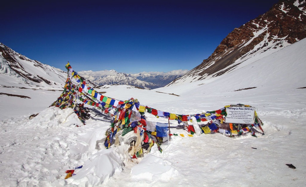
At Thorong La, 5,416 meters, prayer flags and the pass sign mark the crossing from the Manang side of the Annapurna range toward Mustang. We normally stop briefly for a rest and photographs, but we do not plan a fixed amount of time at the top. On a cold or windy morning, it is usually better to begin descending than to remain at the pass simply because it is the highest point of the trek.
One thing we explain before leaving Thorong Phedi is that Thorong La is not the end of the day's work. The route still loses a large amount of elevation before reaching Muktinath. Trekkers who use all their energy trying to reach the pass quickly can find this descent harder than expected, so keeping something in reserve for the second half of the day matters.
The descent requires a different kind of concentration from the climb. Loose ground can be tiring on the legs, while snow or ice, when present, changes how quickly the group can move. Trekking poles are particularly useful on this side of the pass, both for balance and for reducing some of the strain during the prolonged downhill section.
As elevation drops, breathing generally becomes easier, but fatigue from the early start and hours already spent walking can make the final approach to Muktinath feel surprisingly long. Departure time, rest stops and pace are therefore adjusted to the conditions and the group rather than treated as fixed timings that must be followed exactly.
Reaching Muktinath also marks a clear change in the trek. The exposed high ground around Thorong La is behind you, and the route has entered the much drier Mustang side of the Annapurna range. It is this full progression, from leaving Thorong Phedi in darkness to crossing the pass and eventually walking down into Mustang, that defines Thorong La day, not simply the few minutes spent beside the sign at 5,416 meters.
Best Time for Annapurna Thorong La Pass Trek
The best time for the Annapurna Thorong La Pass Trek is generally spring from March to May and autumn from September to November. For a route that crosses Thorong La at 5,416 meters, however, choosing the right month matters more than simply choosing between spring and autumn.
October to early November is our first choice for the strongest overall conditions. After the summer monsoon, the air is generally clearer, the lower trails are drier and mountain visibility is often at its best. October also brings more trekkers to the Annapurna Circuit, particularly around Manang and the main overnight stops. Conditions usually remain favorable into November, but mornings and nights become noticeably colder as the month progresses.
September is a transition month, and we do not treat it exactly like October. The monsoon can still influence the lower part of the route, particularly earlier in the month, with cloud, rain and wetter trails possible in the Marsyangdi Valley. Conditions often improve later in September. Manang and Mustang are considerably drier because of their rain-shadow location, but this 17-day itinerary also passes through wetter sections before and after the high-altitude part of the trek.
March marks the beginning of the main spring trekking season, but winter conditions can still remain around Thorong La. The lower valley may already feel warmer while snow or ice is still present higher on the route. For an early-March departure, we pay particular attention to recent snowfall and current conditions around the pass rather than assuming spring conditions have already arrived everywhere.
April is our preferred spring month for this trek. Temperatures become warmer along the lower route, daylight is longer and conditions around Thorong La are generally more favorable than during winter. It offers a good balance for trekkers who want a spring crossing without the colder conditions more commonly encountered earlier in the season.
May is still a practical trekking month, but the route begins to feel different from April. Lower valleys become warmer, and cloud can build as Nepal moves closer to the summer monsoon. Trekkers who place a high priority on consistently clear mountain views may prefer April or the main autumn period, while May can suit those who prefer warmer temperatures along the lower sections.
We do not normally recommend June to August as the first choice for this complete 17-day route. Manang and Mustang receive much less monsoon rainfall than the southern side of the Annapurna range, but that does not make the entire trek dry during summer. The lower Marsyangdi Valley and the later sections around Tatopani and Ghorepani are more exposed to monsoon rain, bringing wetter trails, cloud and a greater possibility of weather-related disruption.
December to February requires more flexibility and preparation for winter conditions. Clear days are possible, but temperatures at higher elevations become much colder and snowfall can affect the approach to Thorong La and the pass itself. We therefore do not consider winter equivalent to the main spring and autumn trekking seasons simply because a crossing may sometimes be possible.
For most trekkers, our preference is straightforward: October to early November for the strongest overall combination of clearer skies and generally stable trekking conditions, or April for a spring departure with warmer conditions developing along the route. March, May and September can also work well, but each comes with seasonal trade-offs that should be considered before choosing a departure date.
Permits Required for Annapurna Thorong La Pass Trek
The Annapurna Thorong La trekking route passes through the Annapurna Conservation Area, so trekkers need an Annapurna Conservation Area Permit (ACAP). The permit covers the conservation-area sections of this itinerary through Manang, Thorong La, Muktinath, Tatopani and Ghorepani.
For guests trekking with us, we arrange the required ACAP before the trek begins. We normally request the necessary passport details in advance so the permit can be prepared before departure.
There is no separate permit specifically for crossing Thorong La Pass on this itinerary. The route also does not enter Upper Mustang, so an Upper Mustang restricted-area permit is not required.
Trekkers should keep their permit documentation available during the journey because it may be checked at official checkpoints along the route. When trekking with our guide, the normal checkpoint formalities are handled as part of the trip.
Accommodation on the Annapurna Thorong La Trek
Accommodation on the Annapurna Thorong La trek is primarily in mountain tea houses, and the standard varies considerably between the lower Marsyangdi Valley, Manang, the high overnight stops before Thorong La, and the villages after the pass. Most rooms are simple, usually with twin beds, mattresses, pillows and blankets rather than hotel-style facilities.
In larger settlements such as Dharapani, Chame and Manang, there is generally more choice of lodges and better access to facilities such as hot showers, charging and Wi-Fi. Some lodges may have rooms with attached bathrooms, but we do not promise these throughout the route because facilities vary between villages and individual tea houses.
Accommodation becomes noticeably more basic above Manang. Yak Kharka and especially Thorong Phedi have fewer lodging options, and bedrooms are generally not heated. The dining room is usually the warmest shared space in the lodge, particularly in the evening when trekkers gather for meals before returning to their rooms.
At Thorong Phedi, we recommend adjusting expectations about room choice. The purpose of the overnight stop is to eat properly, rest and prepare for the early departure toward Thorong La rather than look for upgraded accommodation. During busy trekking periods, particularly in autumn, lodge capacity can matter more than room preference, so the same flexibility available in Manang should not be expected here.
After Thorong La, accommodation changes again as the route descends through Muktinath and eventually reaches the much lower elevations around Tatopani. The warmer conditions around Tatopani can feel particularly different after the colder nights above Manang. The route then continues toward Ghorepani, where there is again a well-established network of trekking lodges.
Hot showers, battery charging and Wi-Fi are available at many overnight stops, but availability, reliability and cost vary by village and lodge. These services should be treated as useful extras rather than something that will work in the same way every night, particularly around the higher sections of the trek.
When arranging accommodation on this route, we work with what is realistically available in each village rather than promising the same standard throughout the journey. A room in Manang and a room at Thorong Phedi serve very different stages of the trek, and understanding that difference before arriving makes expectations much more realistic.
Food and Drinking Water on the Annapurna Thorong La Trek
Meals on the Annapurna Thorong La trek are served mainly in the tea houses where trekkers stay overnight, with lunch available at villages and tea houses along the walking route. Food choices are generally wider in the lower settlements and Manang, while menus become simpler as the trek climbs toward Yak Kharka and Thorong Phedi.
The most dependable meal throughout the route is dal bhat, usually served with rice, lentil soup, vegetables and seasonal accompaniments. Tea houses also commonly prepare noodles, fried rice, soups, potatoes, eggs, pasta and other straightforward trekking meals. Larger villages such as Chame and Manang generally provide more choice than the higher overnight stops.
Above Manang, we encourage trekkers to think less about having a large menu and more about eating enough for the following day's walking. Appetite can decrease at altitude, so it is worth choosing meals you know you can comfortably finish rather than ordering something simply because it is available.
At Thorong Phedi, dinner and breakfast are part of the preparation for Thorong La day. Because departure for the pass is normally very early, breakfast may need to be arranged with the lodge the evening before. Your guide coordinates the timing so the group can eat before leaving rather than beginning the longest day of the trek without breakfast.
Vegetarian food is widely available along the route and is generally straightforward to manage. Vegan meals can also be arranged at many stops, although the choice becomes narrower at higher elevations. Trekkers with food allergies or specific dietary requirements should tell us before the trek and remind the guide and lodge staff when ordering, particularly at smaller high-altitude tea houses where ingredients and preparation options are more limited.
For drinking water, trekkers do not need to depend entirely on disposable bottled water. Boiled water or locally available water treated with a reliable purification method can be used along the route, depending on the location. Carrying reusable bottles or a hydration system gives you more flexibility between villages and reduces reliance on single-use plastic bottles.
Hot drinking water is available at many tea houses for an additional charge, with prices tending to be higher at the upper stops. We recommend carrying enough water when leaving each village rather than assuming another tea house or reliable water source will appear exactly when you need it.
After crossing Thorong La and descending through Muktinath toward Tatopani and Ghorepani, the range of food generally becomes broader again as the itinerary returns to larger settlements and lower elevations. This can be particularly noticeable after the simpler choices available around the highest part of the route.
For us, eating well on this trek is less about finding special “trekking food” and more about eating regularly, choosing meals your body handles well and maintaining enough energy for consecutive walking days. This becomes particularly important during the higher section between Manang and the Thorong La crossing.
Guide and Porter Support on the Annapurna Thorong La Trek
A trekking guide on the Annapurna Thorong La trek does considerably more than show the trail. Throughout the 17-day journey, the guide manages the daily walking plan, coordinates tea houses and meals, handles normal checkpoint formalities, monitors how trekkers are responding as the route gains altitude, and makes practical decisions when conditions require the day's plan to be adjusted.
The guide's role becomes increasingly important from Manang toward Thorong La. Above 4,000 meters, trekkers may naturally move at different speeds, and we do not expect everyone to maintain exactly the same pace. The guide keeps track of the group, pays attention to changes in how individual trekkers are feeling, and makes decisions based on the condition of the trekkers and the situation on the trail rather than simply trying to keep to a fixed schedule.
A porter is optional on this trek. Our usual arrangement is one porter shared between two trekkers, carrying approximately 20 to 25 kg of combined trekking luggage. This allows trekkers to walk with a lighter daypack while their main trekking bags are carried between the overnight stops.
Even with porter support, you should carry your own drinking water, warm layer, waterproof jacket, sun protection, personal medication, valuables and anything else you may need during the walking day. Your porter may be walking ahead or behind you, so you should not assume that your main bag will be immediately accessible on the trail.
When deciding whether to use a porter, we recommend thinking about the entire 17-day route rather than Thorong La alone. A heavier backpack may feel manageable during the lower days, but carrying it repeatedly becomes more noticeable as fatigue accumulates and the trek climbs beyond Manang. The journey also continues after the pass through Muktinath, Tatopani and Ghorepani, so crossing Thorong La is not the end of the walking.
A porter is not necessary for every trekker. Those accustomed to multi-day trekking with their own pack may prefer to carry independently, while trekkers who want to reduce strain and conserve more energy for the walking itself often find porter support worthwhile. In either case, every trekking section is completed on foot, including the climb to Thorong La and the long descent on the other side.
Transport and Road Conditions on the Annapurna Thorong La Trek
Transport on the Annapurna Thorong La trek is used mainly to avoid road-heavy sections of the modern Annapurna Circuit while keeping the more rewarding mountain sections on foot. Our route travels from Kathmandu to Besisahar first, followed the next day by a shared jeep into the Marsyangdi Valley before the main trekking section begins.
From Besisahar, we use a shared local jeep to Dharapani at around 1,860 meters. The mountain road follows the Marsyangdi Valley through settlements such as Syange, Jagat, Chamje and Tal before reaching Dharapani. The journey can be rough and bumpy, particularly on unpaved sections, and driving time can change with road conditions, traffic, construction and seasonal conditions.
We prefer Dharapani as the walking start rather than driving directly to Chame. Roads now extend far into the lower Annapurna Circuit, and walking every kilometer from Besisahar would mean spending considerable time alongside or close to vehicle tracks. Starting from Dharapani removes much of that road-heavy approach while still keeping the walk from Dharapani through the forested valley toward Chame as part of the trek.
From Dharapani, the journey continues predominantly on foot through Chame, Pisang, Manang, Yak Kharka and Thorong Phedi before crossing Thorong La to Muktinath. This is the core mountain section of the itinerary, and we do not use road transport to shorten the approach between Manang and the pass.
After reaching Muktinath, we use a local bus or shared jeep to travel through the Kali Gandaki corridor toward Tatopani rather than walking for several days beside the motor road. This section has substantial road access, so using transport here allows us to preserve time for the walking section that follows.
The trek begins again from Tatopani toward Ghorepani, leaving the road corridor and climbing back into the hills. After the final walking section from the Ghorepani area, we meet road transport and drive to Pokhara, where the trekking portion of the journey finishes.
Road travel in the Annapurna region should not be treated like highway travel between cities. The Besisahar to Dharapani and Muktinath to Tatopani journeys use mountain roads, and delays can occur because of road maintenance, landslides, rain, traffic or other local conditions. Driving times in the itinerary are therefore estimates rather than guaranteed arrival times.
After completing the trek and staying in Pokhara, the return to Kathmandu is by tourist bus. We recommend keeping some flexibility around onward international travel because both mountain-road journeys and the Pokhara to Kathmandu highway can occasionally take longer than expected.
Packing and Equipment for the Annapurna Thorong La Trek
Packing for the Annapurna Thorong La trek means preparing for very different conditions within the same journey. The lower Marsyangdi Valley and the sections around Tatopani can be relatively warm, while early mornings above Manang and the Thorong La crossing can be cold enough to require proper insulation, gloves and warm head protection.
We recommend using a layering system rather than depending on one heavy jacket. A moisture-managing base layer, insulating mid-layer, warm down or synthetic jacket and waterproof outer shell allow you to adjust as temperature, wind and elevation change. Your warmest layers are particularly important around Thorong Phedi and on Thorong La day, when walking normally begins before sunrise.
For most trekkers, well-broken-in hiking or trekking boots with reliable grip are a practical choice for this route. Fit and familiarity are more important than arriving with new footwear that has never been tested on long walking days. Comfortable trekking socks, basic blister care and lighter footwear for evenings at the tea houses are also useful over a 17-day journey.
Trekking poles are particularly useful on this route. They provide additional stability on uneven ground, but many trekkers appreciate them most during the long descent from Thorong La toward Muktinath and on the later climbs and descents around Ghorepani. If you are unfamiliar with poles, it is better to practice with them before the trek rather than first using them on pass day.
Your daypack should keep water, waterproof and warm layers, sun protection, snacks, personal medication, valuables and other items you may need while walking immediately accessible. Your main trekking bag can contain clothing and equipment that you do not expect to need until reaching the next tea house.
A warm sleeping bag suitable for below-freezing mountain nights is recommended for the higher part of the route. Tea houses provide blankets, but temperatures around the overnight stops above Manang can fall considerably, particularly during colder departures. We prefer trekkers to have an appropriate sleeping system rather than depending entirely on additional lodge blankets.
For Thorong La, microspikes are not automatically necessary on every departure. During normal dry trail conditions, appropriate trekking footwear and poles may be sufficient. Following snowfall or when ice develops on the higher trail, additional traction can become useful. We therefore check recent conditions around the pass rather than telling every trekker to carry the same traction equipment throughout the trekking season.
A headlamp with reliable batteries or spare power is essential for Thorong La day because the crossing normally begins before daylight. Sunglasses with strong UV protection and sunscreen also become increasingly important at altitude, particularly where snow can increase reflected sunlight. Reusable water bottles or a hydration system, water purification and a power bank are practical additions for the complete route.
The final equipment choice should reflect your trekking season and recent conditions around Thorong La, not simply a fixed Annapurna packing list copied for every departure. We pay particular attention to warmth, footwear, waterproof protection and any additional traction needed for the section above Manang, while avoiding unnecessary technical equipment when trail conditions do not require it.
Recommended Packing List
- Daypack: 25 to 35 liters for water, layers and daily essentials
- Main trekking bag or duffel: for clothing and equipment carried between tea houses
- Trekking footwear: well-broken-in hiking or trekking boots with reliable grip
- Trekking poles: especially useful for Thorong La and the long descent toward Muktinath
- Base layers: lightweight moisture-managing tops and bottoms
- Mid-layers: fleece or similar insulation
- Warm jacket: down or synthetic insulated jacket for higher elevations
- Waterproof shell: rain and wind-resistant jacket and trousers
- Trekking trousers: comfortable lightweight and warmer options
- Warm hat and sun hat: for both high-altitude cold and exposed lower trails
- Gloves: warm insulated pair, with lighter liners if preferred
- Trekking socks: several comfortable pairs already tested with your footwear
- Sleeping bag: suitable for below-freezing nights on the higher section
- Headlamp: essential for the pre-dawn Thorong La departure, with spare power
- Sunglasses: good UV protection for high-altitude and possible snow exposure
- Sun protection: sunscreen and lip balm with SPF
- Water storage: reusable bottles or hydration system
- Water purification: tablets, drops or a suitable filtration system
- Personal medication and first-aid items: including blister treatment
- Power bank: useful where charging is limited or charged separately
- Microspikes: only when recent snow or ice conditions around Thorong La make additional traction advisable