Nepal Trekking Route Status - September 2026
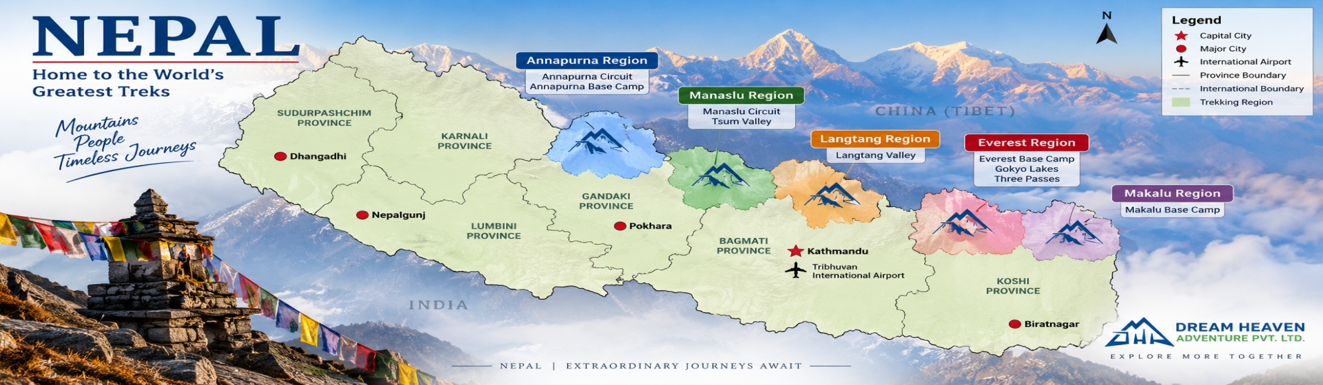
The current situation becomes much clearer when we look at Nepal route by route. The August 26 flood caused catastrophic damage in Rasuwa and along the Bhote Koshi–Trishuli corridor, but Nepal's trekking regions spread across very different valleys and mountain systems. A problem around Syabrubesi does not automatically tell us what is happening in Everest, Annapurna or Mustang.
The situation also changed again on September 6, when separate flooding in the Manaslu region damaged bridges and disrupted part of the trekking route. Manaslu therefore now needs its own current assessment rather than being grouped with trekking regions unaffected by the Rasuwa disaster.
The other important point is access. A trekking destination can remain unaffected higher in the mountains while the road or trail used to reach it is closed or damaged. That distinction is particularly important around Langtang and Manaslu at present.
| Trekking region | Current situation | What trekkers need to know |
|---|
| Langtang Valley & Kyanjin Gompa | Valley route not reported directly affected in the same way as lower Rasuwa, but normal access is seriously disrupted | The normal Rasuwa approach cannot currently be treated as operating normally. We would not operate the standard Langtang itinerary until reliable entry and exit arrangements are confirmed. |
| Everest Base Camp | Not directly affected by the Rasuwa flood | Everest lies in eastern Nepal. For departures here, we are checking Lukla flight operations, mountain weather and information coming from guides on the trail rather than conditions in Rasuwa. |
| Annapurna Base Camp | Not directly affected by the Rasuwa flood | Annapurna lies in a separate trekking region. Road access, recent rainfall and local trail conditions still need their own checks before departure. |
| Annapurna Circuit | Not directly affected by the Rasuwa flood | The trekking corridor is separate from the Rasuwa disaster area. Conditions on approach roads and individual trail sections still need to be checked normally. |
| Manaslu Circuit & Larkya La | Temporary trail disruption following separate flooding on September 6 | Flooding around Therang Khola in Chumnubri has damaged bridges and disrupted the trekking route. The Gorkha administration has advised trekkers to avoid the Manaslu and Larkya Pass routes until further notice. Immediate departures should wait for reliable access to be confirmed. |
| Tsum Valley | Current trail disruption requires confirmation before departure | Recent flooding and landslide activity have affected access on the Manaslu/Tsum side. Trekkers should not assume the standard itinerary is operating normally until the affected sections and crossings are reconfirmed. |
| Upper Mustang | Not directly affected by the Rasuwa flood | Mustang lies in a different part of Nepal. Road or flight access through Pokhara and the Kali Gandaki corridor needs to be judged according to conditions there, not conditions in Rasuwa. |
| Gosaikunda | Destination and normal Rasuwa access need to be considered separately | The usual approach through the affected Rasuwa side cannot currently be treated as normal. Alternative approaches create a different trekking plan and should be checked carefully before departure. |
| Tamang Heritage Trail | Normal itinerary significantly affected by the Rasuwa situation | Because this trek passes through communities and access points within Rasuwa, we would not treat the standard itinerary as operating normally without current confirmation of roads, trails and local conditions. |
What Not Directly Affected; Actually Means
When we say Everest, Annapurna or Upper Mustang was not directly affected by the Rasuwa flood, we are talking specifically about the impact of the August 26 disaster. We are not saying that every road is clear, every flight will leave on time or every mountain trail is free from disruption.
Manaslu is a good example of why the date and location of an update matter. The Manaslu trekking corridor was not directly affected by the August 26 Rasuwa flood around Syabrubesi. However, a separate flood in the Manaslu region on September 6 has now damaged bridges and disrupted part of the route. An accurate statement from one week ago can therefore become incomplete when a new event occurs in another valley.
That difference is easy to miss when looking at Nepal from overseas.
Cloud over Lukla can stop an Everest flight while trekkers already above Namche are walking under clear skies. A road problem can change the driving approach to a trek without affecting the mountain trail itself. In Manaslu today, the issue is different: damage has occurred within the trekking corridor, so we need confirmation of the affected crossings and trail access before treating the normal itinerary as operational. Around Langtang, normal access through Rasuwa remains the major concern.
This is why we do not decide whether a trek can operate simply by asking whether the final destination is open. Before departure, we look at the whole journey: Kathmandu to the trailhead, the walking route through the mountains, and the way the group will come back out.
For Langtang in particular, an alternative trail on a map does not automatically make it a practical replacement for the normal itinerary. It changes the number of trekking days, the direction of travel, logistics and the villages the group passes through. We would only use an alternative approach after checking whether it makes sense for that particular departure.
The same principle now applies to Manaslu. A temporary crossing or local diversion may eventually allow trekking to resume before permanent infrastructure is rebuilt, but we would not advertise the normal route as open until that arrangement is confirmed and practical for trekkers and crew.
Conditions can change quickly during September. A status checked today should therefore not be treated as a guarantee for a departure several weeks from now. We reconfirm the relevant road, flight and trail information closer to the day the group leaves Kathmandu.
What Happened in Rasuwa in August 2026?
On August 26, 2026, a catastrophic flood swept through the Bhote Koshi corridor in Rasuwa and continued downstream into the Trishuli valley. Syabrubesi and Timure were among the badly affected places, with settlements, roads, bridges and hydropower infrastructure suffering severe damage.
For trekkers, Syabrubesi is particularly important. Anyone who has travelled to Langtang knows it as more than a town on the highway. It is the usual road gateway where trekkers arrive from Kathmandu before beginning the walk into the Langtang Valley.
Syabrubesi is the normal gateway for the Langtang Valley Trek, which is why damage to the Rasuwa road corridor matters even when conditions farther inside the valley are different.
After the flood, that normal approach was broken. The road connection between Syabrubesi and Dhunche was severed, bridges were swept away, and sections of the walking route were also damaged. Trekkers already in the Langtang and Gosaikunda areas had to be evacuated through alternative arrangements, including helicopters.
Langtang Valley itself was not directly struck in the same way as the settlements lower down, but that does not mean we can call a normal Langtang itinerary unaffected. If we cannot reliably bring a group to the usual trailhead and know how the group will come back out, the condition of the trail around Lama Hotel, Langtang Village or Kyanjin Gompa is only one part of the decision.
This is something that can be difficult to understand when following the disaster from outside Nepal. A trek does not begin when we take the first step on the mountain trail. For our team, it begins when the group leaves Kathmandu.
The same distinction helps explain why one flood should not be used to describe trekking conditions across the whole country. Everest, Annapurna, Langtang, Manaslu and Mustang use different mountain corridors and different approaches. Conditions have to be checked according to the route and the most recent event affecting it.
For us, the practical question after a disaster is not, “Can we somehow make the itinerary work?” We need to know whether our vehicle can reach the correct starting point, whether our guide and porter can move through the planned route, whether lodges and supplies are functioning, and whether there is a reliable way back out if the situation changes.
Until those pieces are clear, we would rather change or postpone a departure than call a route normal simply because part of the walking trail remains open.
How We Decide Whether a Trek Can Operate After a Flood
After a flood or landslide in Nepal, hearing that a trekking trail is open is only the beginning of the check for us. We still need to know whether we can get the group to the trailhead, whether the planned route works from beginning to end, and whether there is a reliable way back out.
We look at the journey in roughly the same order our trekkers will experience it: the road or flight out of Kathmandu, the trailhead, the walking route, the villages where the group will stay, and finally the exit from the mountains.
We Check How the Group Will Reach the Trailhead
For a trek reached by road, this comes before worrying about conditions several days higher in the mountains.
The present situation on the Prithvi Highway is a good example. At Krishnabhir in Dhading, a section of the highway has collapsed and traffic on the normal highway is currently blocked. Road crews are working on a temporary track above the damaged section, while vehicles travelling between Kathmandu and western Nepal are being diverted through other routes.
For a Manaslu departure, this matters even though Krishnabhir is not on the Manaslu walking trail. We still have to move the group out of Kathmandu and towards Machha Khola before anyone starts trekking beside the Budhi Gandaki.
This is where looking only at a map can be misleading. An alternative road through the hills may appear to solve the problem, but we still need to know what kind of vehicle can use it, how traffic is moving and how much extra driving time it adds. A narrow diversion carrying buses, jeeps and local traffic is very different from travelling on the normal highway.
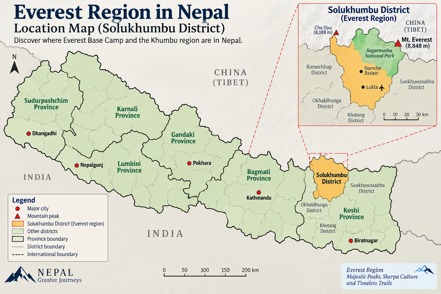
Everest gives us a different type of access problem. If the journey begins with a flight to Lukla, good trail conditions above Phakding do not guarantee that the group will leave on schedule. Cloud, visibility and conditions at the airports can change the first day before the trekkers have even reached the trail.
The same principle applies in Everest. The standard route normally begins with a Lukla flight, while the Everest Base Camp Trek via Salleri uses an overland approach through the lower Solu region before joining the main Everest trail.
We Check What Is Happening Beyond the First Walking Day
Reaching the trailhead does not tell us enough either.
We want information from farther along the route. This can include the condition of bridges and trail sections, whether the lodges we normally use are operating, whether supplies are reaching the higher villages and what our guides and local contacts are hearing from people ahead.
The situation in Manaslu on September 6 shows exactly why this matters. Getting to Machha Khola is only the first part of the operational check. Separate flooding farther inside the Manaslu region has damaged bridges and disrupted the trekking route around Therang Khola in Chumnubri Rural Municipality. Following the damage, the Gorkha administration has advised trekkers to avoid the Manaslu and Larkya Pass routes until further notice.
This means we now have to check both parts of the journey: how the group will reach the trailhead from Kathmandu and whether the affected section farther up the Budhi Gandaki route has a reliable crossing. Only after that can we judge whether the normal journey towards Namrung, Samagaon, Samdo and eventually Larkya La can operate.
It is similar in Everest in the sense that one point on the journey cannot describe the entire route. A normal flight into Lukla tells us very little about what the group may meet several days later around Dingboche, Lobuche or Gorak Shep.
That is why we do not use one report from the trailhead to describe an entire trek.
We Check the Way Back Out Too
Getting trekkers into a mountain valley is only half of an operational plan.
We also need to know how they will leave it.
After major road or bridge damage, this becomes especially important. If another period of rain arrives while the group is trekking, can the planned vehicle still reach the pickup point? Is there a practical alternative if the normal road closes? Would changing the exit add another walking day? Can the guide, porters and trekkers realistically use that alternative with the equipment they are carrying?
Langtang shows why this matters. Even if conditions higher in Langtang Valley are reported as good, serious damage to the normal access through Rasuwa changes both the way trekkers enter the valley and the way they can come back out. We therefore cannot judge the trip only by what the trail looks like around Langtang Village or Kyanjin Gompa.
The new Manaslu disruption adds another example. A temporary crossing or local diversion may eventually make it possible to move through an affected section before permanent infrastructure is rebuilt, but that arrangement still needs to be practical for trekkers, guides and porters before we treat the normal itinerary as operating again.
Today's Road or Trail Report Is Not Next Month's Report
We are particularly careful with dates when publishing an update like this.
As of September 6, the road situation around Krishnabhir is still changing as crews work on a temporary route. The Manaslu situation is also developing as local authorities and communities deal with damaged bridges and trail access.
That information is important for somebody preparing to leave now, but it should not be treated as the condition for a trek beginning several weeks later.
Mountain access can change in both directions. Another spell of rain can close a road or trail that was moving yesterday, while engineers and local communities may restore a damaged crossing that looked impossible to use a week earlier.
For our departures, this means checking again close to the day the group leaves Kathmandu rather than relying on an update saved on a phone several weeks earlier.
If the normal approach or walking route is not practical, the answer is not automatically to force the original itinerary to work. Depending on the situation, we may use a different road, adjust the trekking plan, delay the departure or wait until access becomes reliable again.
The printed itinerary gives us the plan. Conditions on the ground decide how that plan can actually be operated.
Should You Cancel Your Nepal Trek After the Recent Floods?
For most trekkers heading to Everest, Annapurna or Upper Mustang, the August 26 Rasuwa flood alone is not a reason to cancel a Nepal trip. Langtang needs a different decision because normal access through Rasuwa has been seriously disrupted.
Manaslu also needs a separate current assessment following the September 6 flooding within the trekking region itself. Immediate Manaslu Circuit and Larkya Pass departures should follow the latest local authority advice and wait for reliable trail access to be confirmed.
If you already have a trek booked, do not make the decision from the word “flood” in a headline. Check the route you are actually walking, what has happened there, how close you are to departure and when the latest information was verified.
Everest Base Camp
We would not cancel an Everest Base Camp Trek because of the Rasuwa flood.
For an EBC departure, the more relevant questions are whether the journey to the departure airport is running as planned, whether flights to Lukla are operating, and what the weather is doing in the Khumbu.
The Everest Base Camp Trek follows the Khumbu corridor in eastern Nepal, so its access and trail conditions need to be assessed separately from the situation in Rasuwa.
Once trekkers land at Lukla, the journey continues through Phakding and Namche before climbing towards Tengboche, Dingboche, Lobuche and Gorak Shep. Conditions in Rasuwa do not tell us what is happening along that trail.
Flight delays are still possible. Anyone who has operated Everest trips knows that a clear morning in Kathmandu does not guarantee the same visibility at Lukla. We therefore prefer some flexibility around the flight schedule rather than treating an expected departure time as a guarantee.
Annapurna
We would take the same approach with Annapurna Base Camp or the Annapurna Circuit: do not cancel solely because of the Rasuwa flood.
Instead, check the access used by your particular itinerary. An Annapurna Base Camp trek beginning from the Pokhara side has different transport concerns from an Annapurna Circuit itinerary heading towards its own starting point.
For a September departure, recent rainfall still deserves attention. For a trek beginning several weeks later in October or November, today's road report is much less useful. We would check again closer to departure rather than assume early-September conditions will remain unchanged.
Manaslu Circuit
Manaslu now needs a different answer from the one we would have given immediately after the August 26 Rasuwa flood.
The Rasuwa disaster did not directly affect the Manaslu trekking corridor. However, on September 6, separate flooding within the Manaslu region damaged bridges and disrupted part of the trekking route around Therang Khola in Chumnubri Rural Municipality. The Gorkha administration has advised trekkers to avoid the Manaslu and Larkya Pass routes until further notice.
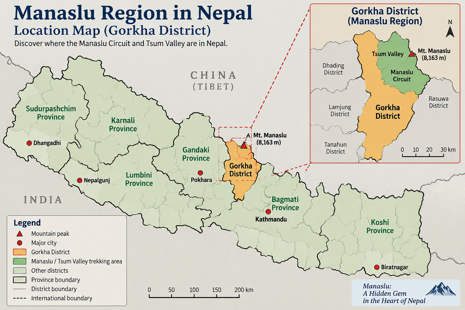
For somebody scheduled to begin the Manaslu Circuit immediately, we would therefore not advise proceeding on the normal itinerary until reliable access through the affected section is confirmed.
This does not mean we should assume that the Manaslu Circuit will remain unavailable throughout the autumn trekking season. Temporary crossings, trail repairs and local access arrangements can change the situation, but we do not want to predict a reopening date before those arrangements are actually usable.
For trekkers booked for later in September, October or November, we would keep the planned trip under review rather than cancel solely because of today's report. The useful information will be whether the affected crossing has been restored or a reliable alternative has been established by the time that particular group is due to enter the Budhi Gandaki Valley.
There is still a separate road question before the trek begins. Groups travelling from Kathmandu towards Machha Khola depend on the wider highway network, so both the driving approach and the trekking route now need to be reconfirmed before departure.
For Manaslu at present, reaching Machha Khola is not enough. We need to know that the route farther up the valley is workable too.
Upper Mustang
There is no reason to cancel an Upper Mustang trek specifically because of the Rasuwa flood.
Mustang has its own access through Pokhara and the Kali Gandaki corridor. Those road or flight conditions should be checked independently.
This is one reason we avoid giving the whole country a single trekking status. A transport or trail problem in one valley may have little relevance to a trek several mountain regions away.
Langtang
Langtang is another route where our answer changes.
For somebody departing soon, we would not treat the standard Langtang itinerary as operating normally until reliable access through the usual approach is confirmed.
Finding another trail on a map does not automatically solve that problem. An alternative approach can change the starting point, walking days, daily distances, porter logistics, accommodation plan and the way the group returns.
For a Langtang trek several weeks or months away, however, cancelling immediately may also be premature. Repair work and access can change. The decision should be made using the latest information available closer to departure.
When Would We Actually Change a Trek?
We would consider delaying, rerouting or changing an itinerary when a problem affects something essential to operating the journey: reaching the trailhead, crossing a critical bridge or trail section, finding a reliable exit, keeping the planned walking days realistic, or maintaining the accommodation and supplies needed along the route.
The current situations in Langtang and Manaslu show two different ways this can happen. In Langtang, the major concern is the damaged normal approach through Rasuwa. In Manaslu, the September 6 flooding has created a separate problem farther inside the trekking corridor where bridge and trail access now need to be reconfirmed.
Sometimes an alternative road is enough. Sometimes a temporary crossing or an extra day solves the problem. Sometimes delaying or changing the itinerary is the sensible choice.
What we would not do is force the original program simply because it appears on a booking confirmation.
A trekking itinerary is a plan made in Kathmandu. The final decision has to make sense in the mountains.
What Trekkers Should Do Before Traveling to Nepal Now
If your trek is going ahead, you do not need to rebuild the whole journey around what happened in Rasuwa or Manaslu. What you do need is enough flexibility to deal with a road, flight or trail situation that may be different from the one shown in your original itinerary.
For our departures, there are a few things we prefer trekkers to have sorted before leaving home.
Do Not Change an International Flight Because of Today's Road Report
A road closure inside Nepal and an international flight into Kathmandu are two different parts of the journey.
If your trek begins several weeks from now, a highway report from today is not enough reason to change an international ticket. A damaged section may still be under repair when you arrive, it may have reopened, or vehicles may be using a different approach by then.
The useful question is not, “What is the road like today?” It is, “How are we reaching my trailhead when my trek starts?”
That is the question we check again closer to departure.
Keep 1-2 Buffer Days in Kathmandu
Where your schedule allows, we recommend keeping one or two buffer days in Kathmandu after the trek and before your international flight home.
Those days are useful when a mountain journey does not finish exactly according to the printed itinerary. A Lukla flight may be delayed by weather, a road journey can take longer than expected, or a temporary trail or transport problem may require the guide to adjust the plan.
For Everest trekkers, the buffer is particularly useful because Lukla flights depend heavily on mountain weather. For road-based treks such as Manaslu and Annapurna, it also gives some breathing room if a highway delay makes the return journey longer than planned.
We prefer keeping these days after the trek rather than filling every available day before the international departure. If everything runs on schedule, you simply have an extra day or two in Kathmandu. If something changes in the mountains, those days become part of the contingency plan.
One or two buffer days cannot protect against every prolonged disruption, but for most trekking itineraries they provide a sensible margin without unnecessarily extending the trip.
Ask About Your Route, Not Whether “Nepal Is Safe”
A few days before leaving home, contact your trekking company again.
Instead of asking whether everything in Nepal is normal, ask:
“For my departure date, how are we reaching the trailhead, and is the route I am walking operating as planned?”
That question should produce a much more useful answer than a general “everything is fine.”
For a road-access trek, ask whether the normal road is being used, whether a diversion is expected and whether it changes the driving time.
For Everest, check the current Lukla flight arrangement and whether anything has changed in the transport needed to reach the departure airport.
For routes where access has been directly disrupted, such as Langtang and Manaslu at present, we would want the complete entry, trail and exit situation to be clear before treating the original itinerary as operating normally.
For Langtang, the major question remains reliable access through Rasuwa. For Manaslu, the September 6 bridge and trail disruption means we also need confirmation from farther inside the trekking corridor before an immediate departure proceeds.
Check What Your Insurance Actually Covers
Do not assume that buying “travel insurance” automatically means you are covered for everything that can happen on a Himalayan trek.
Check the maximum trekking altitude allowed by the policy and read the conditions for emergency evacuation, medical treatment, trip interruption, delays and natural disasters. Different insurers and policies have different limits and exclusions.
This matters on high routes. Everest Base Camp reaches 5,364 metres, Kala Patthar is higher, and Larkya La on the Manaslu Circuit is above 5,000 metres. A policy with an altitude limit below the highest point of your itinerary is not suitable simply because it includes trekking cover.
Keep your insurer's emergency contact details and policy information somewhere you can reach even when mobile data is poor. We also prefer our guide to know which insurer a trekker is using before the group heads into the higher mountains.
Keep Essentials With You on a Longer Road Day
A diversion around a damaged highway can turn an already long transfer into a much longer day.
Do not put everything you may need inside the duffel or suitcase loaded into the vehicle. Keep drinking water, a few snacks, medication you need during the day, a waterproof layer, phone or power bank and important documents in the small bag beside you.
This becomes particularly useful when traffic stops on a narrow mountain road. Your main luggage may be packed underneath other bags or secured where it is not practical to reach every time the vehicle stops.
Treat the Morning of Departure as Another Checkpoint
The final check does not happen when we send the itinerary.
A road situation can change overnight. Mountain weather can change before the first flight to Lukla. A guide returning from the same route may bring information that was not available several days earlier. A bridge or trail situation can also change as temporary repairs or alternative crossings are established.
So we check again before the group leaves Kathmandu.
That does not mean changing an itinerary every time there is cloud over the hills or rain in the forecast. It means knowing which part of the journey is actually affected and adjusting the plan when there is a practical reason to do so.
In Nepal, flexibility is most useful when it is built into the trip before you need it.
Where to Check Current Nepal Trekking and Road Conditions
After a flood or landslide in Nepal, information can change quickly. The difficult part is not finding an update; it is knowing whether that update applies to the road, flight or trekking route you will actually use.
A video of a damaged highway can continue circulating after vehicles have started using a diversion. A photograph from Rasuwa may be shared without making it clear that Everest or Annapurna is hundreds of kilometres away. The opposite can happen too: an older post saying a road is open may no longer be useful after another night of rain.
This is why we do not make a departure decision from one Facebook post, one news report or one phone call.
We Start With the Official Situation
For a major event affecting travelers, we first want to understand the wider situation.
The Nepal Tourism Board (NTB) publishes tourism notices and traveler information. For highways and road disruptions, information may come from the Department of Roads, Nepal Police or the relevant local authorities. For rainfall and weather warnings, Nepal's Department of Hydrology and Meteorology (DHM) is more useful than treating the weather symbol on a general phone app as a forecast for an entire Himalayan valley.
Official information gives us the larger picture. It does not always tell us what the group will find at 7:00 tomorrow morning when the jeep leaves Kathmandu.
That requires another layer of checking.
Then We Bring the Check Down to the Actual Route
As departure gets closer, the questions become much more specific.
Is the road simply marked open, or are vehicles actually moving through it? Is a diversion suitable for the vehicle we planned to use? Has the driving time changed? Are the lodges on the planned itinerary operating? Has a bridge or trail section created a problem farther ahead?
This is where information from drivers, guides, lodge operators and local contacts along the route becomes useful.
A Manaslu group does not need a general statement that “Nepal trekking is open.” We need to know whether the vehicle can make the journey towards Machha Khola and what is happening farther up the Budhi Gandaki route. The September 6 disruption is a good example of why both questions matter.
For Everest, a highway report from Rasuwa tells us very little. We are more interested in the day's Lukla flight situation, Khumbu weather and information coming from the trail.
For Langtang at present, the opposite is true. Conditions around the Rasuwa approach are directly relevant because that is how the normal journey reaches the trekking side.
Check When the Information Was Actually Recorded
This is one of the easiest details to miss after a natural disaster.
When you see a road photograph, trail video or social-media post, check when the situation shown actually happened, not only when somebody uploaded or shared it.
A three-day-old photograph can look dramatic and still be genuine, but it may no longer describe the road or trail you will meet today.
The same rule applies to this article. Our September 6, 2026 update describes the situation we can verify now. Someone trekking several weeks later should not use it as their final road or trail report.
For our own departures, we check the relevant information again closer to the day the group leaves Kathmandu.
“Open” Does Not Always Mean “Normal”
This distinction is particularly important on Nepal's roads and trekking trails.
A road can technically reopen while traffic is moving slowly through a temporary track. A diversion can be available but add hours to the journey. A jeep may be able to pass somewhere that we would not choose for a larger vehicle.
The same principle applies in the mountains. A trail being described as open does not tell us whether every bridge, lodge, supply connection or exit route is operating exactly as it did before the disruption.
A temporary crossing may allow local movement before we consider it suitable for a normal trekking itinerary with clients, guides, porters and their equipment.
So when somebody tells us a route is open, our next question is usually:
“Open for what, and under what conditions?”
That answer is much more useful when planning a real departure.
Be Careful With Both “Nepal Is Safe” and “Nepal Is Unsafe”
Neither statement is specific enough to plan a trek.
What we need to know is:
Which road is affected? Which trailhead does it serve? Which trekking itinerary uses it? Has damage occurred farther along the walking route? When was the information checked? What are vehicles and trekkers actually doing now?
That is the difference between reading an update and being able to use it.
For trekking operations, specific, dated and route-based information is more useful than either a reassuring or alarming headline about Nepal as a whole.
What Does This Mean for September, October and November 2026 Treks?
A trek beginning this week and a trek beginning six weeks from now should not be judged from the same road or trail report.
That matters particularly this autumn. September still falls within Nepal's late-monsoon period, while recent flooding has caused serious infrastructure damage in Rasuwa and, in a separate September 6 event, new trail disruption in the Manaslu region. Parts of the wider road network have also been affected.
By October and November, some of today's problems may have changed considerably, but we would not promise that simply because the trekking season has moved on. Repairs, temporary crossings, road diversions and local access arrangements develop according to conditions on the ground, not according to the trekking calendar.
Trekking in September 2026
For September departures, we pay close attention to the most recent road, trail and weather information because conditions can change within a short period.
After repeated monsoon rain, slopes can remain saturated and lower trails and mountain roads may still be wet. Further rainfall can bring loose material onto a road, slow traffic, raise streams or affect a trail section that was passable earlier.
For trekkers leaving Kathmandu now, flexibility on the driving day matters. A journey that normally takes a certain number of hours can take considerably longer when traffic is diverted or moving slowly through a temporary route.
The same principle applies farther inside a trekking region. On Manaslu, for example, the September 6 flooding has damaged bridges and disrupted part of the trekking route around Therang Khola. The Gorkha administration has advised trekkers to avoid the Manaslu and Larkya Pass routes until further notice. An immediate Manaslu departure therefore needs more than confirmation that the road to Machha Khola is usable. We also need reliable access through the affected section farther up the valley.
Langtang requires a different type of check. The major concern there remains serious disruption to the normal approach through Rasuwa, so we would not treat the standard Langtang itinerary as operating normally until reliable entry and exit are confirmed.
This does not mean every September trek in Nepal is disrupted. It means we give today's information much more weight for a departure tomorrow than we would for a trek beginning several weeks from now.
Trekking in October 2026
October is one of Nepal's main trekking months, and many autumn departures are planned for this period.
If your Everest, Annapurna or Upper Mustang trek begins in October, we would not change the trip now simply because a particular road or trekking region is disrupted in early September. The useful check should be made much closer to departure and should focus on the road, flight and trail your itinerary actually uses.
Manaslu needs to be treated separately. The current September 6 disruption is directly within the trekking region, and the Gorkha administration has advised trekkers to avoid the Manaslu and Larkya Pass routes until further notice. We would therefore continue monitoring an October Manaslu departure rather than assume either that the route will remain disrupted or that it will definitely reopen by then.
There is still time for temporary crossings, repairs or alternative access arrangements to change the situation. What matters for an October departure is whether reliable access has actually been established and what the current official and local information says when the trek is approaching.
Langtang also needs a more cautious approach because the August flood seriously disrupted its normal access corridor. An October Langtang departure should therefore be reviewed against the actual recovery and access situation rather than assuming the beginning of peak trekking season will automatically return the standard itinerary to normal.
Road repair, temporary diversions and local access do not follow the trekking calendar. For us, the practical approach is to keep later departures under review and make the operational decision using information available closer to the day the group leaves Kathmandu.
Trekking in November 2026
For somebody trekking in November, a September road or trail report has even less value as a prediction.
By then, what matters is what has actually been repaired, which roads, bridges and trailheads are operating, whether any temporary arrangements have become reliable, and what guides and local contacts are finding on the route at that time.
This applies to both Langtang and Manaslu. We would not use the September 6 situation as a prediction of what either route will look like two months later. We would check the actual November access conditions before making the operational decision.
The mountain conditions also begin to change as autumn moves towards winter. Nights become colder at altitude, daylight gradually shortens, and fresh snowfall can become more important on itineraries crossing high points such as Larkya La or Thorong La.
Those are different operational questions from the August Rasuwa flood or the September Manaslu disruption.
A November trek should therefore be checked for November conditions, not treated as an extension of a September emergency update.
Today's Road or Trail Condition Is Not an Autumn Forecast
This is particularly important for travelers researching their trek from overseas.
A road closure or damaged trail reported on September 6 tells us what is happening on or around September 6. It does not prove that the same problem will remain in October or November, and it does not guarantee that it will be resolved either.
The same caution applies when a road or trail first reopens. “Open” may mean traffic is passing through a temporary track, vehicles are moving only at certain times, or a diversion is still adding hours to the journey. In the mountains, a temporary crossing may allow local movement without yet being suitable for a normal trekking group with guides, porters and equipment.
For our autumn groups, we therefore keep later departures under review where appropriate and make the operational decision using information available closer to departure.
We plan the trekking season months ahead, but we operate each departure using the conditions we have on the ground at that time.
Nepal Trekking Safety After the 2026 Floods: FAQs
Is trekking in Nepal safe after the 2026 Rasuwa flood?
The August 26 Rasuwa flood did not affect every trekking region in Nepal in the same way. Langtang and the Rasuwa side need particular attention because normal access has been seriously disrupted, while Everest, Annapurna and Upper Mustang lie in different trekking regions.
Manaslu was not directly affected by the Rasuwa disaster, but a separate flood on September 6 has since damaged bridges and disrupted part of the Manaslu trekking route.
The useful question is therefore not whether all of Nepal is safe, but whether the road, flight and trail needed for your particular trek are operating for your departure date.
Which trekking area in Nepal has been most affected by the Rasuwa flood?
Langtang is the major trekking area where normal access has been most directly disrupted by the August 26 Rasuwa disaster.
Syabrubesi, normally the road gateway for the Langtang Valley Trek, suffered serious damage. This does not mean every section of trail higher in Langtang Valley was destroyed, but reliable entry and exit through the normal approach remain essential before operating the standard itinerary.
The September 6 disruption in Manaslu is a separate event and should not be confused with the Rasuwa flood.
Is Everest Base Camp affected by the Rasuwa flood?
The August 26 Rasuwa flood did not directly affect the Everest Base Camp trekking corridor.
Everest lies in eastern Nepal, away from the Rasuwa disaster area. For an EBC departure, we are more concerned with the current Lukla flight arrangement, Khumbu weather, trail conditions and the normal high-altitude considerations than with flood damage around Syabrubesi.
Is the Manaslu Circuit affected by the Rasuwa flood?
The August 26 Rasuwa flood did not directly affect the Manaslu Circuit, which follows the Budhi Gandaki Valley in a different mountain region.
However, a separate flood on September 6 around Therang Khola in Chumnubri Rural Municipality damaged bridges and disrupted part of the Manaslu trekking route. The Gorkha administration has advised trekkers to avoid the Manaslu and Larkya Pass routes until further notice.
For an immediate departure, we would therefore wait for reliable access through the affected section to be confirmed. For a trek later in the autumn, check again closer to departure rather than assuming today's disruption will either continue or be resolved by then.
Is Annapurna trekking affected by the Rasuwa flood?
The August 26 Rasuwa flood did not directly affect the Annapurna Base Camp or Annapurna Circuit trekking corridors.
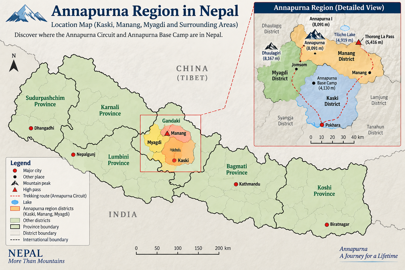
Annapurna has different trailheads and access routes. Road conditions, recent rainfall and local trail conditions should therefore be checked for the actual Annapurna itinerary rather than inferred from what is happening in Rasuwa.
Can I trek to Langtang Valley now?
At present, we would not treat the standard Langtang itinerary as operating normally until reliable access through the usual Rasuwa approach is confirmed.
The condition of Langtang Valley itself and the condition of the route used to reach it are separate questions. Even if trails and lodges higher around Langtang Village or Kyanjin Gompa are functioning, trekkers and crew still need a reliable entry and exit plan.
If you are planning Langtang, check again close to your departure because recovery and access conditions can change.
Should I cancel my Nepal trek because of the floods?
Not solely because flooding has occurred somewhere in Nepal.
For Everest, Annapurna or Upper Mustang, check the conditions relevant to your particular itinerary before making a cancellation decision.
For Langtang, the decision needs to reflect the latest Rasuwa access situation. For Manaslu, immediate departures require particular attention because the September 6 flooding has disrupted part of the trekking route and authorities have advised trekkers to avoid the Manaslu and Larkya Pass routes until further notice.
For a Manaslu trek several weeks or months away, cancelling immediately may be premature. The route should be reassessed using the latest official and local information closer to departure.
Will trekking conditions in Nepal be normal by October 2026?
Nobody can responsibly guarantee in early September that every damaged road, bridge or access route will be back to normal in October.
For Everest, Annapurna and other trekking regions not directly affected by these particular floods, a September disruption elsewhere in Nepal is not by itself a reason to cancel an October departure.
For Langtang, October departures should be assessed according to the actual progress of access and recovery. For Manaslu, the September 6 trail disruption and current official advice need to be monitored separately. We would not promise today that the route will be normal in October, but neither would we assume that today's situation will remain unchanged.
The useful check is the one made closer to the actual departure date.
How many buffer days should I keep for trekking in Nepal?
Where your schedule allows, we recommend keeping one or two buffer days in Kathmandu after the trek and before your international flight home.
They are particularly useful for Everest itineraries involving Lukla flights, but they also provide flexibility if a road journey or trekking schedule takes longer than planned.
One or two days cannot cover every prolonged disruption, but they provide a sensible margin for most trekking itineraries.
Where should I check the latest Nepal trekking conditions?
Start with dated information from official sources such as the Nepal Tourism Board, relevant road and local authorities, and Nepal's Department of Hydrology and Meteorology for weather information.
Then ask your trekking operator about the exact journey you are taking:
How will you reach the trailhead? Is the planned walking route operating? Is the exit route clear? When was this information last checked?
For a route affected by a recent event, also ask whether the latest official advice has changed and whether temporary access is actually suitable for a trekking group.
Those answers are more useful than a general statement that Nepal is either “safe” or “unsafe.”